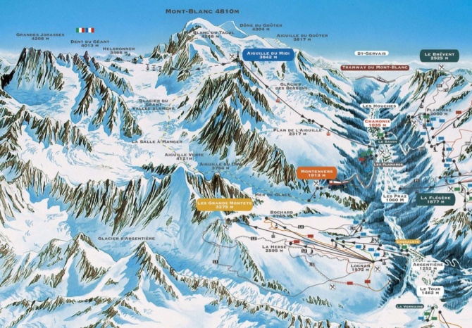
I’m finally back with some pictures I took during my ski-holiday in Chamonix, on the French side of Mont Blanc (or Monte Bianco, as we Italians would call it on our side 🙂 ).
I spent most of the time on ski tracks, however I couldn’t help but bring my camera in the backpack whenever the weather would allow it.
The pictures posted here have been taken on two very special days. The first set has been taken from the top of Aiguille des Grand Montets (3295m), the highest tip of the ski resort bearing the same name.
From up there a magnificent view opens in every direction: looking East the shiny white Argentiere Glacier sprawls from ramparts of Mont Dolent (3823m) down to the Chamonix valley, skirting Aiguille d’Argentiere (3901m) and Aiguille du Chardonnet (3824m). To the South, the view is completely dominated by the towering 4122m of Aiguille Verte, while as you move your sight to the South-West the panorama opens up to reveal the massive complex of Mont Blanc, which with its 4810m is the highest mountain in Europe. At the opposite side, from North to South-West, lies the Chamonix valley with the towns of Argentiere, Chamonix and Les Houches, backgrounded by the massif of Aiguilles Rouges.
I took the second set from atop the Aiguille du Midi (3842m), a peak in the Mont Blanc massif which can be handily reached from Chamonix via a stunning cable car. Panorama from Aiguille du Midi is even more breathtaking: looking South-East, from one side to the other and as far as one’s eye can see, countless mountains and peaks crowd the view in the distance (including two of the most beautiful mountains in the Alps: Mount Rosa and Mount Cervino), while the huge mass of the Mont Blanc is towering to the South. Down below the huge Glacier du Geant and the Vallée Blanche fill the sight of a sparkling, shining white. Behind you, nearly 3Km below, lies Chamonix on the bottom of the valley.


